Texas is heading into a potentially impactful winter weather setup as an Arctic cold front is forecast to move into the state late Friday, January 23, with the coldest conditions and highest winter precipitation risk expected between Saturday, January 24, and early Sunday. While the exact placement and intensity of snow, sleet, and freezing rain remain uncertain—as is typical with Texas winter storms—the large-scale pattern supports a sharp temperature drop and widespread cold across the state.
This system is being driven by a polar vortex disruption, allowing Arctic air to surge southward into Texas and much of the southeastern United States. Below is a clear breakdown of what’s happening, why it’s happening, and what Texans should realistically be paying attention to.
What’s Causing This Arctic Cold Front
The polar vortex is a broad circulation of extremely cold air that usually stays concentrated near the Arctic. Periodically, atmospheric shifts weaken its containment, allowing lobes of Arctic air to move south into the continental United States.
When that Arctic air pushes into Texas behind a strong cold front, the result is an Arctic blast—a rapid temperature drop often accompanied by winter precipitation if moisture is present. That is the pattern currently being monitored for late this week.
Temperature Outlook: Rapid Cooling Is the Main Certainty
While precipitation outcomes remain variable, temperature changes are highly likely.
Friday, January 23:
Many areas of Texas—especially Central Texas—may reach highs near 65–70°F ahead of the front. As the front passes later in the day or evening, temperatures are expected to fall rapidly, with strong north winds ushering in colder air.Saturday, January 24:
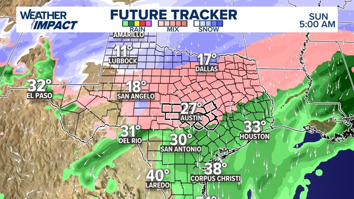
Much of Texas is expected to be at or below freezing, particularly overnight and during the early morning hours. This period represents the highest risk window for winter precipitation where moisture overlaps with cold air.Sunday, January 25 into Monday, January 26:
Precipitation chances decrease, but cold conditions linger, with continued freeze potential overnight and during early mornings.
Winter Precipitation Risk: Snow vs. Ice Depends on Location
North Texas & the Texas Panhandle
Highest probability of snow
Arctic air is deeper and more consistent
Snow or a snow/sleet mix is possible from Friday night through Sunday
Accumulations remain uncertain but could impact travel
Central Texas (Austin & Hill Country)
Lower probability of snow
Higher probability of freezing rain and sleet
This region often sits near the freezing line, creating conditions where rain freezes on contact
Ice accumulation poses the greatest risk to roads, bridges, and power lines
South & Southeast Texas
Precipitation likely begins as rain
Freezing rain becomes possible if colder air arrives faster than expected
Snow is unlikely, but icy conditions cannot be ruled out
Why Ice Is the Bigger Concern Than Snow in Central Texas
Ice is typically more disruptive than snow in Texas.
Even small amounts can make roads impassable
Ice adds weight to trees and power lines
Bridges and elevated roadways freeze first
Ice lingers longer when temperatures stay below freezing
For Austin and much of Central Texas, freezing rain and sleet represent the primary hazard, not snowfall totals.
Regional Impact Beyond Texas
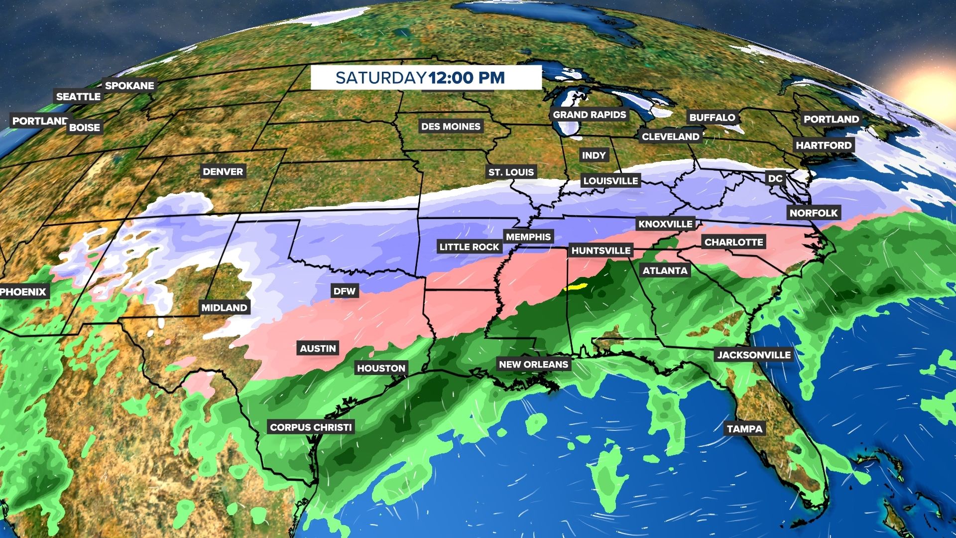
This storm system is expected to impact a broad portion of the Southeastern United States, including:
Oklahoma
Louisiana
Mississippi
Alabama
Georgia
The Carolinas
Tennessee
Virginia
Maryland
Winter precipitation types will vary by region, but snow and ice impacts are possible well beyond Texas as the system shifts eastward over the weekend.
After the Precipitation: Why the Cold Still Matters
Even after precipitation tapers off:
Overnight freezes may persist
Any ice on roads can refreeze
Pipes, plants, and unprotected infrastructure remain vulnerable
Post-storm cold is often when secondary damage occurs, especially if people assume the risk has passed.
ERCOT and the Economic Reality (One Section, Straight Talk)
Every Arctic cold front brings renewed attention to Texas’ power grid.
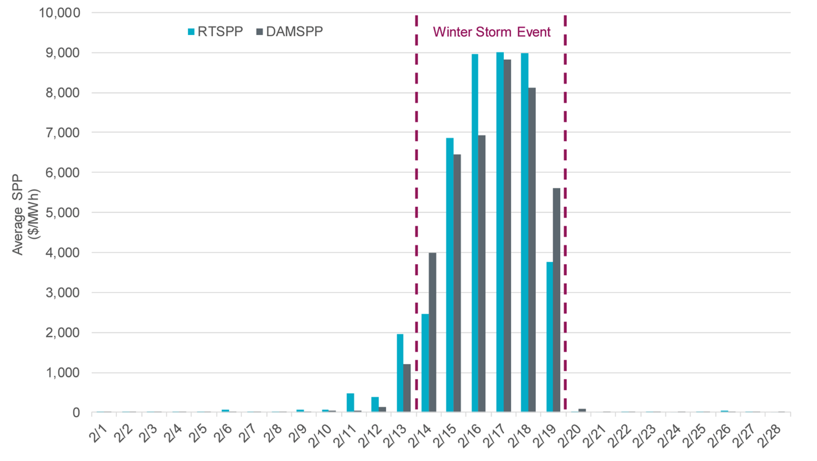
The last major winter freeze resulted in more than $16 billion in excess electricity charges, largely tied to pricing mechanisms during peak demand. While state leaders and grid operators say improvements have been made, extreme cold still stresses the system, particularly during early mornings and evenings when heating demand spikes.
This event will serve as another test—not just of infrastructure, but of market safeguards and preparedness.

Source: ERCOT Operational Overview
What Texans Should Know Going Into the Weekend
Friday evening through Saturday is the most critical period
Snow is most likely in North Texas
Ice is the primary concern for Central Texas
Cold temperatures may linger even after precipitation ends
Preparation matters more than exact snowfall totals
Bottom Line
This is a classic Arctic blast scenario driven by a polar vortex disruption. While the exact details of snow and ice are still evolving, the temperature plunge is nearly guaranteed, and winter weather impacts are possible across large portions of Texas and the Southeast.
Texans should stay weather-aware, plan for rapid changes, and take the cold seriously—even if this storm does not reach historic levels.


